
|
||
|
Issue 66 |
|
17 May 2012 |
|
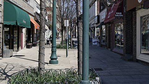 "They did it with Photoshop." This is not a real street in Summit, NJ. See just below for more on this technique. AnnouncementsVideoI have continued making videos this spring, although I am running out of material. One of the newest releases, "With Cars or Without" is embedded below, and you can watch it in HD if your connection is fast enough:
|
|
|
|
The technique is simple. Only three photographs are required, one straight down the left-hand curb, another straight down the right-hand curb, and one straight down the centerline of the street. The first two photographs are chopped off at the curb and welded into a single image that appears to show a narrow pedestrian street. The comparison with reality (the third photograph) is always stark.
A personal favorite is "For the Love of Venice" (in full 1080p if you have the hardware):
|
|
|
|
There may be restrictions on embedding this latter video as SME retains rights to the soundtrack. There are a number of other, shorter videos in the past couple of months. You can watch them all at:
Vimeo (up to 720p)
If you watch a video, please Like it by mousing over and clicking the Heart icon in the top-right of the video frame (Vimeo) or clicking the Thumbs Up icon below the video (YouTube). Posting to Twitter and Facebook will also help if you can. We need to get the message out to a broader audience. We have passed the 10,000-views mark but still need a much larger audience. Most of the films are released under a Creative Commons Non-Commercial Attribution license, so you're free to do anything you like with those as long as you acknowledge the source. I would have simply put them in the public domain, but I used other Creative Commons-licensed material that requires the same terms and conditions. I will probably shoot more footage this summer in southern Europe. Piscataquis VillageThe Piscataquis Village project was mentioned briefly a few months ago on the Carfree_Cities Yahoo group (open to the general public). With the publication of this issue I am announcing my support for the project by signing up for a share in the community, which Tracy Gayton hopes to establish near the geographic center of the US state of Maine. Mr Gayton has been kind enough to supply a brief introduction to the project in this issue. This would be the first truly carfree district constructed in the USA since the dawn of the automobile age.Final Round of Changes to Carfree TimesI think I am finally satisfied with the changes that have been made to Carfree Times over the past several issues. I have decided to stay with the very short format of News Bits items. We'll be looking for more Feature Articles in the future, and they will come above the News Bits items. This issue has three Feature Articles. So, if you'd like to write for Carfree Times, please drop me an e-mail.Photo Archive UpdatedWith silver photography, quality only declines with age. Fortunately, with digital photography, the quality actually improves. This is the result of extraordinarily powerful digital processing tools that have become available. I use a program called DxO to process the original camera files into images with a quality that appears impossible to attain from looking at the source material. I only use this program because it delivers exceptional results. Otherwise, it drives me crazy, so no warranties here!I have reprocessed all of the better images that I shot with the Nikon D70 in 2005 and 2006. This is a large archive, and considerably improved images are now available in the Digital Photographs section of the Design Library at Carfree.com. If you have linked to any of these images, they will automatically update in all locations where you have used them, and they are the same width as formerly. (The height might differ by a couple of pixels due to geometric corrections applied by DxO.) So far, only the horizontal images have been updated. The BooksCarfree Cities and Carfree Design Manual are widely available in Europe and North America.World Carfree NetworkCarfree.com actively supports World Carfree Network (WCN). The network stands at the point of some degree of renewal and rebirth and could use your help if you have time available.World Carfree NewsWorld Carfree News is now available in Czech, English, French, German, Italian, Portuguese, and Spanish. It's published monthly and is a great way to keep abreast of important developments in the carfree cities network.3rd International Conference on Degrowth for Ecological Sustainability and Social EquityVenice, 19-23 September 2012This is not directly an initiative of WCN, but many present and former WCN members are involved, and WCN may hold its own meeting just before or after the conference. Since the conference is in Venice, it will be easy to tempt lovers of carfree cities to attend. More information. If you are thinking of attending either the conference or the WCN meeting, please let me know by e-mail.
|
|
 Mount Katahdin, Maine ©2011 Lisa Adkins Feature ArticlePiscataquis VillageBy Tracy GaytonA group of Maine residents is mounting an effort to create a compact, carfree micropolis in one of the most rural counties in eastern United States. Piscataquis County, encompassing the terminus of the 2,100 mile Appalachian Trail at Maine's mile-high Mt. Katahdin and Moosehead Lake (Maine's largest), is almost the size of the entire state of Connecticut, but has a population of just 17,500 people.
 Piscataquis River, Maine ©2011 Lisa Adkins The Piscataquis Village Project has not yet identified a specific site. They plan on acquiring a parcel of land of approximately 500 acres in size, 125 acres of which will be developed incrementally as a mixed-use residential village at a density of from 35 to 50 dwelling units per acre. The remaining 375 acres, other than space for motor vehicle parking at the Village perimeter, will be reserved for recreation and small scale agriculture.
 Guilford, Maine ©2011 Lisa Adkins The project organizers do not intend to construct buildings or to micromanage specific building design. They believe that the most successful places are places where individuals and groups are free to do as they like as long as they don't infringe upon the freedom of their neighbors. Though they also recognize that in any settlement where people are brought together in close proximity, practically speaking, some agreed-upon covenants will need to be established. The organizers believe that the function of the project is to:
 Peaks-Kenney/Sebec Lake, Maine ©2011 Lisa Adkins The original founders of the project, many of whom have roots in Piscataquis County that go back for generations, are intent on creating for themselves a world-class, quality community in the place where they live. If approved as proposed, it is thought that this would be the largest approved carfree development in the USA and also perhaps the only one of any kind where implementation of the proposed design code would guide development to approximate the traditional village/city pattern of Europe or early North America. This development is also viewed as a vehicle for retaining and attracting new residents to the county, with positive benefits extending to existing towns and institutions, while the pinprick-sized footprint of the proposed Village ensures that the prized rural character of the County remains virtually untouched. The Piscataquis Village Project is utilizing a "kick-starter" model to raise investment capital for the proposal. Non-legally binding investment pledges in the minimum amount of $10,000 are committed, contingent upon the project receiving the total $2,000,000 thought needed to break ground. Investors receive an unimproved building lot within the development, a plot of land in the green/agricultural zone, car parking space at the perimeter, four bonus building lots which may be conveyed to first-time homeowners, and an investment share in the project commensurate with the amount invested.
 Wharff Road, Guilford, Maine ©2011 Lisa Adkins An alternative investment option is offered to self-forming groups of twenty or more for a $5,000 pledge per household. This is offered to encourage collaborations with groups comprised of friends, families, and organizations such as cohousing groups, art colonies, eco-villages, or community housing and development organizations. Early residents are expected to be people living in the county and working in nearby towns, retirees, and those with home-based businesses. Though it is the most sparsely populated county east of the Mississippi River, Piscataquis is only a four-hour drive from Boston or Quebec City and offers a refuge for those wishing to own a pied-à-terre in a rural area rich in natural resources. A slide presentation of the proposal was created in August 2011, and so far the group has received investment pledges from 25 households for a total of $300,000.
Tracy Gayton moved to Piscataquis County, Maine,
where he built an off-grid home after hiking the Appalachian Trail in 1984. He worked at Bangor Savings Bank for 17 years as a Branch Manager and Regional Vice-President. Active in the community, he was a founding board member of Center Theatre, finance committee member of Womancare/Aegis Domestic Violence Project, and also sat on the boards of the Penquis Mental Health Association, the Maine Highlands Art Guild, and the Piscataquis County Economic Development Council. After leaving work in 2005, he has lived and traveled extensively in South America and Europe, where he had an opportunity to observe, first hand, cities and villages built in the compact, traditional pattern. In March 2011 he established a website for the Piscataquis Village Project and since then has worked to advance a proposal to establish a carfree micropolis in central Maine. Feature ArticleSingapore: So Close and Yet . . .By Debra Efroymson One of several entrances for cars to Fort Canning Park, Singapore ©2012 Debra Efroymson It might seem obvious that if you want to make your city liveable, you have to implement measures to drastically reduce the cars. If you really wish for your city to be liveable, then there is no choice but eventually to squeeze them out of the city altogether. Nor should getting rid of cars be considered a sacrifice; without the cars, the conditions for walking, cycling, pedicabs, and public transport (preferably trams) would be such good quality that really nobody should even miss the cars. But when I talk to different people about liveable cities, while some see the same holistic vision as I do, others are brutally stubborn about such points as the perceived need to accommodate/ encourage cars, or to provide abundant parking. Yet such actions would limit the effectiveness of all the good things they do seem to understand. And that inability to give up certain traditional planning ideas plays out in cities around the world.
 A street segment that gets it right: Little India, Singapore ©2012 Debra Efroymson Take Singapore, famous in transport planning circles for its successful efforts to control car use. The government had little choice: as with Hong Kong, there is limited space and a lot of money, so without car controls, the entire city-state would be one constant traffic jam. Although the controls may have been weakened somewhat in recent years, it is still extremely expensive to own a car in Singapore (to be fair, life in general is extremely expensive; apparently most apartments are subsidized by the government), and the city has also implemented congestion charges in the central area. As a result, Singapore has kept cars to the numbers where the traffic consistently flows (questionable though it is whether that is a pro- or anti-car measure). Government officials also seem to realize that if you don't want people to drive, you need to give them good alternatives. The public transport system is of high quality: it is quite easy to figure out, trains and buses seem to come at frequent intervals, and at least at one bus interchange, there are separate marked lanes for different buses, so that everyone queues up in a neat and orderly fashion (again rather revolutionary for Asia) to board the bus when it arrives. I had a moment of panic at hearing I needed to make two transfers from my hotel to the airport; in other cities, such as Boston or Bangkok, that would involve staircases and long unpleasant corridors. But in fact all I had to do was cross half a platform, and everything was well-marked (in all four official languages). 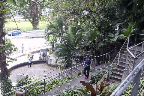 Pedestrian shortcut between Fort Canning Park and Orchard Road, Singapore ©2012 Debra Efroymson All the streets seem to have sidewalks, and the intersections have pedestrian crossing signals (this might not seem so surprising, but is still rare in other parts of Asia). So, it is quite possible to walk in the city, and this is in stark contrast to what one sees in Dhaka and too many other Asian cities, where pedestrians are reduced to darting between motorized vehicles. But even Singapore could do far better. Take cycling, which could be an extremely convenient and useful mode in a city that is basically flat, not terribly large, and very expensive. I did see several cyclists, including groups of young men with expensive bikes. But in terms of official recognition of cycling, it only took the form of signs telling people not to cycle. At Clarke Quay, for instance, a popular tourist destination, where many people are out walking, there were several signs prohibiting cycling (with a fine of $1,000!!). Yet in the beautiful Fort Canning Park just across a busy street from the quay, cars are allowed to enter a significant portion of the park and car parking takes up a good deal of space that otherwise could be set aside for human activity.  Steps and foliage in Fort Canning Park, Singapore ©2012 Debra Efroymson And while one has moments in Singapore of wondering if one is truly in Asia, the general attitude of the drivers towards those not in a car reminded me precisely where I was; overall the drivers showed no respect or consideration to pedestrians or cyclists. As for walking, it involves far more patience than the tropical weather gives rise to. For one thing, you have to push for a walk signal, so if you approach an intersection shortly after the traffic in your direction has started, you get a little red man, despite having more than ample time to cross. Then, some of the intersections have the red man appear long, long before the signal for cars changes. Discovering this, I learned to go despite the red man. . . but when I tried it at other intersections, I had to run to keep from being hit. So the timing of the pedestrian signal varies widely at different intersections. Apparently this is what happens when you put traffic engineers in charge of pedestrian crossings: no consideration as to how long pedestrians must wait or how reasonably timed the crossings are. 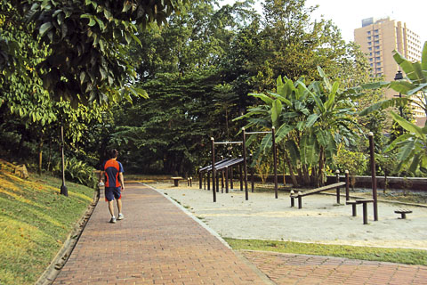 An exercise/workout/fitness area in Fort Canning Park, Singapore ©2012 Debra Efroymson Of course this should be taken in perspective. Having traveled there from Dhaka, the city in many ways seemed a paradise. Although Singapore is a strange and rather artificial place, it also shows just how well things can work in Asia. . . so it's even more disappointing when they get something so important so wrong.
Debra Efroymson is Regional Director for HealthBridge,
a Canadian NGO which in addition to its more traditional public health programs also works on Liveable Cities. Debra has lived and worked for 16 years in Asia and has spoken and written abundantly on issues of non-motorized transport, liveable cities, and carfree issues. Feature ArticleThe City of Bangalore and Its Approach to the 21st CenturyBy Manju George Commercial Street, Bangalore, India ©2012 ESAF The city of Bangalore has a long history of leading technological innovation in India. (In 2005, the government accepted a proposal to rename the city to Bengaluru, but the change is not yet officially implemented.) Bangalore enjoys a benign climate and is flat except for a central ridge. Under the British influence, the city bloomed with modern facilities such as railways, telegraph, schools, health care, water, post, and police departments. These world-class facilities lured people to the city, initially from within Karnataka state and later from around the world. Migration was rapid between 1941-51 and again between 1971-81. The manufacturing sector grew following the establishment of private companies. Due to migration, the real estate market boomed, leading to the conversion of large plots and colonial bungalows to multi-story apartments in the 1980s and 90s. However, rapid development of the city outstripped its water supply, and in dry years some areas suffer water shortages.
 Commercial Street in the morning ©2012 ESAF Texas Instruments was the first large foreign corporation to establish a base in Bangalore. Many other technology companies followed, and by the year 2000 Bangalore had been dubbed the "Silicon Valley of India." The first car began polluting the city in 1903, and the thirst for personal luxury slowly defeated public transport. Though the government has struggled to operate decent public transport across the city, the lack of thought to last-mile connectivity led to a flood of private vehicles once high-paying jobs arrived in the city. Today the city is one of the most polluted cities in India. Heavy to severe air pollution in high-traffic areas already existed by 2005 and has worsened under the burden of the increasing number of vehicles since then. The Pedestrian Environment and Indian RoadsInfrastructure developments in Indian cities almost invariably accommodate private vehicles at the expense of public transport. Each year more vehicles are added, and the roads become steadily more congested. Investment focuses on widening roads, constructing flyovers and express highways, and other car-focused infrastructure, so the situation steadily worsens. Worse still, most construction ignores guidelines that call for amenities such as footpaths (sidewalks), medians, pedestrian crossings, and so forth. This failure has put the pedestrian in a perilous situation. Pedestrian spaces are routinely usurped by road development.
 Pedestrians walking in Commercial Street ©2012 ESAF We Indians are accustomed to walking in the road, though whether this is due to habit or necessity is debatable. In any case, motorcycles and mopeds often use the footpaths, thereby endangering pedestrians, especially elders and children. The footpaths are often uneven, broken, and occupied by garbage and construction material. In the neighbourhood of elite housing colonies, this space has been utilized for beautifying the area fronting the houses, again forcing the pedestrian into the road at the risk of his life.
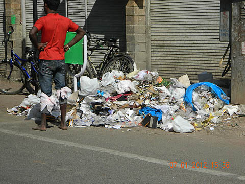 Trash in Commercial Street ©2012 ESAF In commercial areas, footpaths are again of limited use, often because of encroachment by vendors and shopkeepers to display their signs and wares. Although street vendors promote affordable wares and community vibrancy, and are thus infinitely preferable to vehicle encroachment, in the absence of proper controls for their placement they can also impinge on pedestrian space and block footpaths. Finally, the demand for ever more parking leads to the encroachment on playgrounds, parks, and even river beds: for instance, the largest bus station in central Bangalore, Kempegowda Bus Terminus, occupies the Dharmanbudhi lake bed. All told, the sad reality is that the pedestrian is almost universally ignored by urban planners.
 Commercial Street by day ©2012 ESAF This is not to say that pedestrians are always badly treated throughout the country. For example, walking plazas in M. G. Road in Pune were very successful, and reports show that both shoppers and merchants are using the pedestrian-friendly street. However, following the November 26 terror attacks on Mumbai, safety has become an increased concern, and Pune closed down the walking plazas. Though efforts have been made to restore them, this has not yet been achieved. Further, carfree days in India have created some awareness of the benefits of pedestrian spaces. However, unless the government takes the lead role in initiating and implementing pedestrian improvements, the program will attain neither the sustainability nor the success that it has elsewhere in the world.
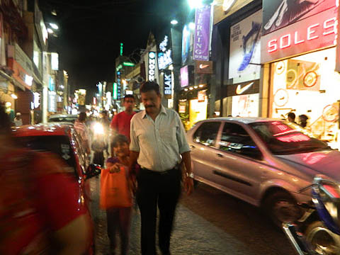 Evening in Commercial Street ©2012 ESAF An Introduction to Commercial StreetIn Bangalore, known for its excellent shopping, Commercial Street is one of the oldest, most popular shopping areas. It is situated in the Central Business District and is one of the three most lively shopping areas in town. Commercial Street, a British legacy, sells both international brands and locally-produced items. "Shopping" and "women" are synonymous in Bangalore, and merchants are clearly aware of this. Almost 75% of the shops cater exclusively to women. Garments, hosiery, textiles, and shoes comprise the bulk of goods. In addition, there are shops selling artifacts and art materials, jewelry, food, hardware goods, sporting goods, and general goods. The term "Commercial Street" includes the adjacent by-lanes.
 Intense motorized traffic in Commercial Street ©2012 ESAF Many of the old buildings that were on Commercial Street have been pulled down to make way for large modern buildings. Once the place was a mixed-use neighborhood, comprising residential as well as commercial space, but as the city expanded and gave more importance to commerce, people moved away, and the residential space was converted to purely commercial space. Just a handful of families still live on the street above their business. As business has increased, Sunday closures ceased and the place is now open for business every day of the year. This once-quiet street is now a busy area where people fight for parking spaces as well as pedestrian rights.
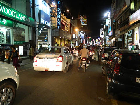 Parked cars and traffic in Commercial Street ©2012 ESAF Could Commercial Street be Pedestrianised: Research ResultsIn order to assess the possibility of pedestrianisation and the likely reaction of merchants, research was conducted with merchants on the street. They clearly consider the shopping malls mushrooming nearby as a major threat to their livelihood. They assume that only by having parking facilities can their customers be enticed back to the street. In addition to discussions with merchants, researchers also surveyed shoppers at nearby malls and on Commercial Street. The study was conducted by Mr. Das.Survey of the Merchants
 Competition for street space in Commercial Street ©2012 ESAF Survey of Mall PatronsThe mall patrons who still visit Commercial Street mentioned the following reasons for the street losing its charm:
When asked why they shopped at a mall, only 19% indicated that parking was the main reason. Although this was the largest single response by percentage, this is by no means the majority of mall shoppers. Other reasons included:
 Dense pedestrian traffic in Commercial Street ©2012 ESAF When asked about the shopping experience on Commercial Street, lack of parking was raised as an issue by only 17% of respondents, so this may not be as big an issue as the merchants believe. The customers clearly want a safe, comfortable street. The fact that shopping malls provide a carfree environment is something that people typically appreciate without realizing the reason. Evangelical Social Action Forum (ESAF), HealthBridge (HB), and Pedestrian-Friendly StreetsIn 2009, with support from the Canadian NGO HB, ESAF started a Livable Cities Program (with special attention to the needs of children) in two states of India: Bangalore and Nagpur. The first year saw extensive studies in both the states to determine the existing conditions, based on transportation indicators, safety, health education, neighbourhood, land use, and governance. The children and other stakeholders were unhappy with the existing conditions. Children were especially vocal as to their needs and priorities. In Bangalore, they highlighted the need for safe routes to school (the majority of the children walk); better facilities, such as more public transport during school hours; better amenities in schools, parks, and playgrounds; and various policies to implement and monitor these programs.In Bangalore, the area selected for the trial version of how to make a public space exciting and lively was Commercial Street. An important criterion was a street that is not a thoroughfare. As seen in the above survey results, the merchants and their association are very concerned about losing business. They think that those who come by car give them more business than those on foot. Many merchants believe their business can be improved by inviting the most vehicle-dependent shoppers. Many merchants have traveled abroad and experienced pedestrian streets in other parts of the world. However, they feel that the attitude of Indians precludes such a program from succeeding locally. In many families, having two cars has become usual. People prefer personal vehicles to public transport. The fact that far more pedestrians than car passengers use the street seems lost on the merchants, if not the shoppers themselves. Past Efforts in Commercial StreetVarious efforts to make the street pedestrian-friendly have been made since 2003. One excellent plan would have divided the 11-meter-wide road with medians, a park, and a play area specially designed for children, with fountains and other attractions. A nearby parking garage would have been constructed. Alas, the plan was derailed by objections on the part of the powerful Merchants' Association.
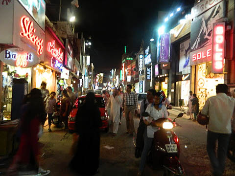 Commercial Street bustles after dark ©2012 ESAF ESAF and HealthBridge have taken up this scenario despite the many difficulties. After all, there is a long history of cities that ultimately became pedestrian-friendly only after years of failed attempts. In the long run, people typically understand the benefits of going car-free and decide to try it. Once they get a taste of it, people long for it, with the once-opposed merchants often defending the policy the loudest, and so the program eventually succeeds. There is no reason why India should be an exception to this global rule. Future Plans of ESAF and HB for a Pedestrian-Friendly Commercial StreetOngoing and future activities to promote a pedestrianised Commercial Street include:
ConclusionWe are promoting the pedestrianisation of Commercial Street for many reasons. The street is losing its charm. Many public places which children and adults once used for recreation and socialisation have been taken away by development, with the city converted into a concrete jungle that people despise.These changes have led to inactive people utterly reliant on motor vehicles. Creativity is destroyed because more time is spent watching television and playing video games. Young people become less tolerant and more irritable, with poor problem-solving and communication skills. The coping mechanisms of the current generation seem poor compared to the time when there were rich interactions in the streets. But none of these problems are inevitable or irreversible; we are determined that our efforts will lead to a return of lively streets and liveable cities, beginning in Bangalore and Nagpur, and extending far, far beyond.
Manju George, Mental Health professional from NIMHANS,
works as Program Officer for "Livable City Program" with Evangelical Social Action Forum (ESAF) in partnership with HealthBridge, Canada.
ESAF is a pioneering organisation working in India for
The full paper, City of Bangalore and its approach to 21st Century, News BitsThe articles I consider most important come first. The links below will open in a new browser window:
"Piscataquis Village on Google Docs"
"How Cities Can Learn to Ride Bikes"
"Traditional City/Heroic Materialism Series Archive"
"This is it, so sorry no-one was ready: Climate chaos = sudden actions"
"Crude-Oil Extraction Resurgent in the United States?: No [PDF!]"
"IKEA is Assembling its Own London Neighborhood "
"The solar envelope: how to heat and cool cities without fossil fuels"
"The age of speed: how to reduce global fuel consumption by 75 percent"
"New Data Visualization Tool Encourages Sustainable Buildings in Sydney"
"The Crisis in American Walking"
"The Street Hacker, Officially Embraced"
Back to Carfree.com
E-mail
|